Investigating the Impact of Sea Level Rise on Tidal Marshes of Hyde County
By Allie Best
The Importance of Marshes
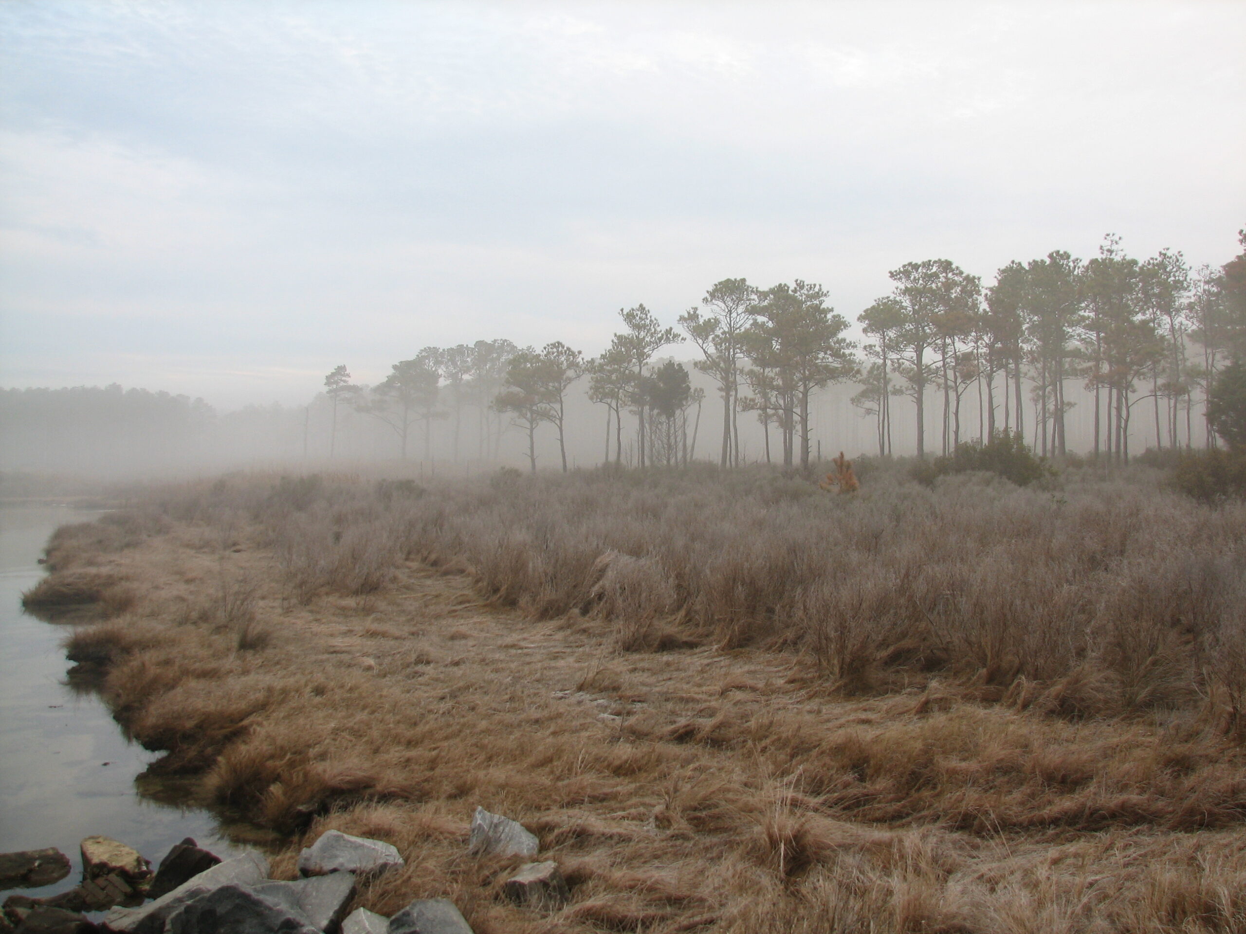
If you have had an opportunity to spend time along the coast of North Carolina, you most likely have seen a tidal marsh — sometimes without even knowing it. Marshes are often in low-lying areas near bodies of water that flow into grassy areas.
Beyond the natural beauty of marshes, these areas also provide valuable ecosystem services that are vital to society and wildlife. For example, tidal marsh habitats often serve as areas for fishing and hunting; act as a form of protection for the coastline; and play a role in removing carbon dioxide from the atmosphere.
These habitats also function as nurseries for commercially important fish, increasing the economic value of the area. In fact, it is estimated that salt marshes contribute $37.8 billion along the Atlantic coast alone.
Another form of tourism common in and near marshes is birding. Every year, especially during migration seasons, thousands of avid birders travel to areas all along our coast in hopes of getting a peak at some of their favorite birds, and maybe some unusual visitors.
Furthermore, observations from hurricanes have demonstrated that marshes act as buffers because they can reduce storm surge height and resist water flow. This ability reduces property and flood damage costs adding to marshes’ economic benefits. Also, recent studies have indicated that salt marshes are more efficient at pulling carbon dioxide from the atmosphere than tropical rain forests.
In addition to the benefits tidal marshes provide directly to society, they also serve as important habitats for a wide diversity of species. As their name may imply, tidal marshes are influenced by the tide. At high tides, these areas are covered by more water than at low tides.
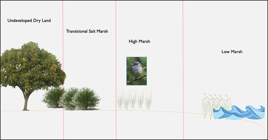
An interesting aspect of tidal marshes is that they can be characterized into different zones based on the amount of water that they receive at high tides. Areas of higher elevation will receive less water than those lying closer to the ground. These areas are in fact so different that they provide habitat for different groups of species, both plants and animals.
Sea Level Rise
Despite the critical ecological services that marshes provide, they are one of the most degraded ecosystems around the globe. Tidal marshes along the coast of North Carolina are experiencing an average relative sea level rise of 3.63 mm/yr, according to the National Oceanic and Atmospheric Administration.
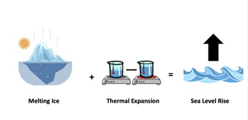
How is this happening? As temperatures are becoming warmer, glacial areas are starting to melt. This melting ice adds a large volume of water to our existing oceans. Additionally, when water is warmer it has a natural tendency to expand, which also adds volume.
If you live along the coast or travel to these areas for vacation you may have noticed some areas that have already seen changes as a result of sea level rise. More frequent coastal flooding and coastline erosion are two prominent impacts of sea level rise that threaten properties and important habitat. A major area of research has focused on predicting what will happen to these important tidal marsh areas as our sea levels continue to rise.
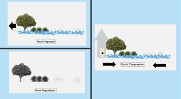
Scientists report that marshes will react in three primary methods: marsh migration, marsh compression, and marsh degradation. When given enough area, marshes will continuously migrate backward more inland. However, as coastal development increases and property owners continue to build hardened structures, the marsh will not be able to move. As a result, marshes will be compressed into smaller areas. Finally, when neither of these options are available, the marsh will degrade into a mostly unusable habitat. It is, therefore, important to study different tidal marsh areas to determine available options for land managers to develop appropriate conservation plans.
Investigating Tidal Marshes of Hyde County, NC
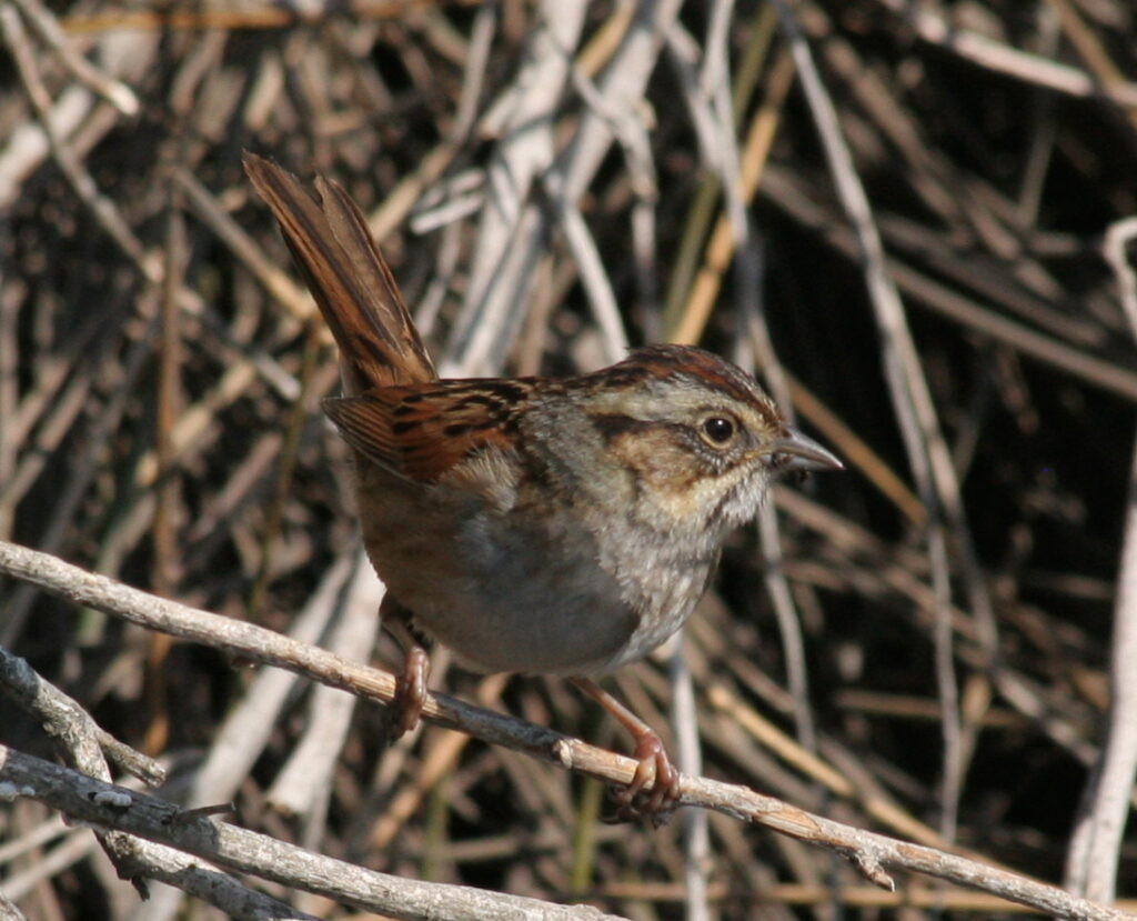
My research focuses on the high marsh, or irregularly flooded, zone of tidal marshes that serve as prime habitat for swamp sparrows (Melospiza georgiana). The irregularly flooded marsh habitat is differentiated from the low marsh, or regularly flooded habitat, based on the regularity of flooding and the species of vegetation found there. According to NOAA, high marsh zones are not flooded often, while lower lying marshes are flooded twice daily with the tides.
Swamp sparrows are one of the many bird species that occupy high-marsh habitats during the nonbreeding season. The swamp sparrow has three subspecies: Coastal Plain Swamp Sparrow (M. g. nigrescens), and two interior subspecies (the Southern Swamp Sparrow, M. g. georgiana and the Northern Swamp Sparrow, M. g. ericrypta) that are often lumped together as the inland swamp sparrow due to physical similarities. Currently, the Coastal Plain Swamp Sparrow is listed as a taxon of highest priority for conservation by the Salt Marsh Bird Conservation Plan.
I addressed two primary questions:
- What area of the marsh do Swamp Sparrows prefer to use?
- How is sea level rise in this area expected to change these habitats?
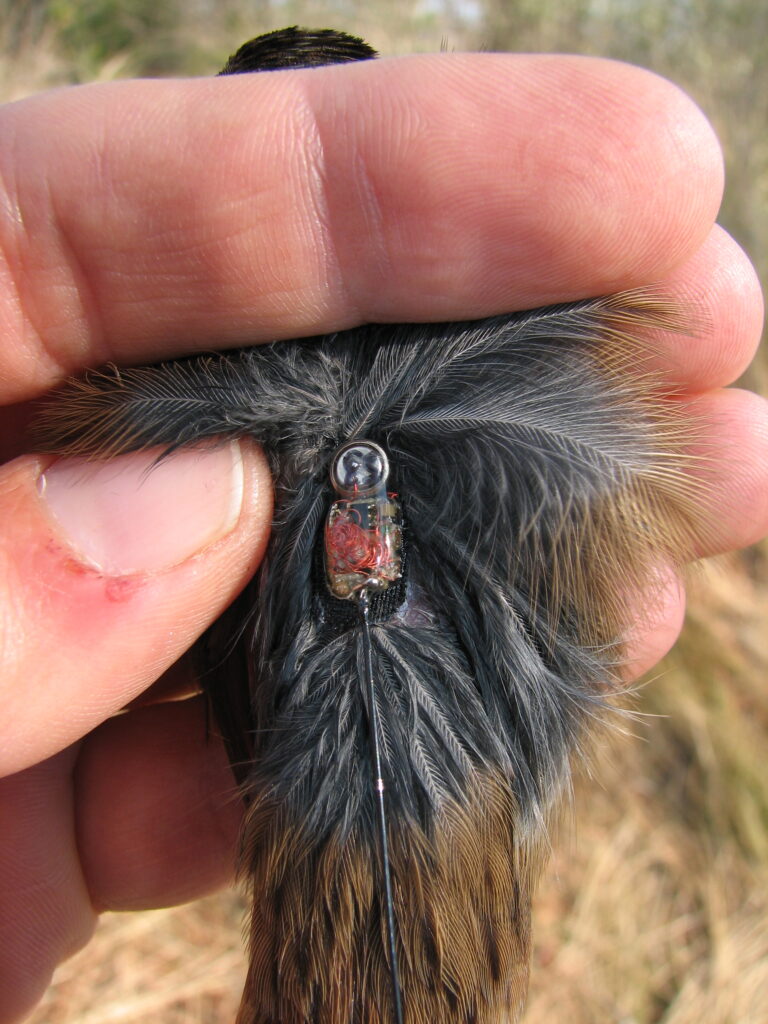
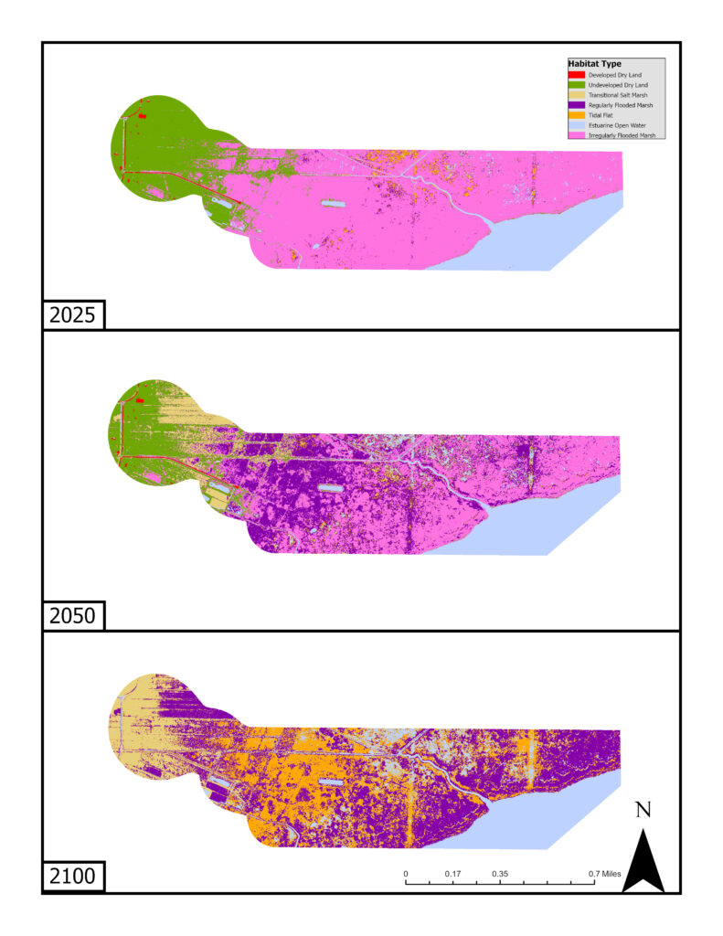
I used radio telemetry data that my advisor, Raymond Danner, of the University of North Carolina Wilmington, collected in the winters of 2008-2010 to determine the type of habitat that swamp sparrows used. Radio telemetry uses radio signals to determine location. Then, I used satellite imagery to classify the different habitats present within the swamp sparrows movement area, or home range, at four different study sites. I used these habitat classifications to develop sea level rise models using a Sea Level Rise Affecting Marshes Model (SLAMM). We used these models to determine how much prime swamp sparrow habitat may be lost as a result of sea level rise in the years 2025, 2050, 2100.
Key Findings
Indeed, sea level rise is predicted to alter the habitat of the tidal marshes in Hyde County through 2100. Although we saw a change in habitat for each year we modeled sea level rise (2025, 2050, and 2100), the largest change we saw was between 2050 and 2100. Overall, there was a reduction in irregularly flooded marsh, prime swamp sparrow habitat, at every site at the low, intermediate, and high sea level rise projections.
Average Irregularly Flooded Marsh Habitat Percentage Across Four Study Sites
| Year | ||||
| Scenario | Initial Condition | 2025 | 2050 | 2100 |
| Low | 44.03 | 43.51 | 31.02 | 9.85 |
| Intermediate | 44.03 | 43.34 | 31.02 | 1.06 |
| High | 44.03 | 43.08 | 25.05 | 0.85 |
Looking ahead, it is important to determine what options resource managers may have for each area, as they try to reduce the drastic habitat changes we are predicting to see as a result of sea level rise. However, it may be unrealistic to save all areas that are experiencing changes as a result of sea level rise. In such cases, it is important to determine what this area’s habitats will likely change to to determine if other species, also under threat, may be able to use them.
For example, as sea levels rise, irregularly flooded marshes are expected to transition into regularly flooded marshes. Swamp sparrows have not been seen to use these areas regularly, but this may provide additional habitat for other species that currently need the lower-lying marshes to survive.
Look For Yourself
As I was completing my research for this fellowship, I was blown away by the power of accessible data. Throughout my scientific career, I have worked extremely closely with a relatively small group of people. With this project, specifically developing sea level rise predictions, I extended my circle to include multiple organizations, universities and peers. The scientific community is vast and diverse, and I found that different opinions provide varying perspectives about certain aspects of climate change.
I also found that you can be a more efficient scientist by taking advantage of the tools at your disposal. There is a lot of publicly available data out there, and we need even more. For example, I used data from NASA and NOAA to determine my sea level rise predictions; however, I could have benefited from more data regarding the rates of accretion in a variety of different habitats.
As such, I have created an open-access interactive web map that allows users to look at how the habitat is predicted to change across different years using an intermediate sea level rise projection. My hope is that this program will allow users to see where these sparrows have been found in the past to predict what types of habitats may be available in the future. This is yet another example of open access data that can be used to engage and support students and the greater community.
Above all, I think that this fellowship has shown me the importance of continuing to be curious. Throughout this project, I continued to develop more questions that I attempted to answer by widening the depth of this research. I am excited to see what types of questions that individuals will have once they have an opportunity to look at the data I have provided and read more about the impact of sea level rise in marsh habitat — these questions will be the catalyst to developing mitigation techniques to protect these habitats in the future.
This online interactive map demonstrates how sea level rise may impact tidal marshes and Swamp Sparrow habitat. As mentioned, this map was developed from research conducted by Allie Best, and the data collection from this research occurred at four sites in Hyde County, North Carolina.
Each layer corresponds to the intermediate sea level rise prediction for a different year (2025, 2050, and 2100). The map also contains location data for swamp sparrows over the course of this research study. Each point corresponds to a known location of a swamp sparrow; the colors correspond to the subspecies (Coastal Plain subspecies in blue and Inland subspecies in red). Toggling between the layers, viewers can see how sea level rise is predicted to impact tidal marshes over time.
Teach About Sea Level Rise
For educators interested in teaching about the impact of sea level rise, Allie Best has put together an interactive slideshow, map, lesson plan and worksheet for educators’ use.
The lesson plan includes the learning objectives met as well as guiding notes for educators to use throughout the lesson. After the lesson, educators may use the student worksheet to assess students’ knowledge. Students will need to use the interactive map to complete the worksheet. Educators may use the teacher labeled worksheet to check students’ work.
The learning objectives met including the following Biology and Earth/Environmental Sciences Standards in the NC Standard Course of Study.
Learning objectives met:
- Bio.5.1 → Use mathematics and computational thinking to explain how interactions between organisms (predator/prey, competition) affect carrying capacity and maintain stability in an ecosystem.
- Bio.5.2 → Engage in argument from evidence to evaluate various solutions to reduce the impact of human activities on biodiversity and ecosystem health.
- EES.5.6 → Construct an argument to evaluate a range of solutions to mitigate impacts of human activities on Earth’s systems.
If you’ve taught this lesson or plan on doing so, please let NC Space Grant and NC Sea Grant know using this form.
Materials
Sources
Salt Marsh Bird Conservation Plan for the Atlantic Coast. 2019. Atlantic Coast Joint Venture. www.acjv.org
Narayan, S., M. W. Beck, P. Wilson, C. J. Thomas, A. Guerrero, C. C. Shepard, B. G. Reguero, G. Franco, J. C. Ingram, and D. Trespalacios. 2017. The Value of Coastal Wetlands for Flood Damage Reduction in the Northeastern USA. Scientific Reports 7.
NOAA. 2023. Tides and Currents. https://tidesandcurrents.noaa.gov/
Allie Best is an M.S. student at the University of North Carolina at Wilmington. Best was a 2022-23 North Carolina Sea Grant – North Carolina Space Grant Graduate Research Fellow.
☽
- Categories: